The coalmine at Waterschei (that name literally means
watershed) is one of seven in the Campine coal basin. The concession named André Dumont-sous-Asch was granted in
1906 after André Dumont had found coal in the village of As (Asch in French) in 1901. The village
counsel of As rejected the foundation of a colliery within its borders as they
feared large scale immigration, pollution and negative effects on agriculture.
The colliery was therefore to be located on the other side of the heath near
the hamlet of Waterschei within the parish of Genk on the edge of the arable
fields.
Work on sinking the first pit was started in 1912
using the Foraky-method. The work was troubled by set-backs resulting in the
pit being completely flooded in 1914. Work on sinking the second pit was started
during the first half of 1914 without many problems. Work on both pits was suspended
during the Great War to be completed in 1922 (pit 1) and 1928 (pit 2). The
first coal was extracted in 1924. Both pit towers are identical and date from
1922. Between 1920 an 1924 a large
representative office building with large hall, bathhouse, changing rooms,
directors suite, administration, payment counters and lamp distribution
counters was erected on the edge of the site near the Stiemersbeek, a brook
that was at first brought underground and now feeds a series of ornamental
ponds.

The offices of the colliery were housed in this imposing
structure with a tower on the corner and an enormous central hall over two
floors with a large window on the front facade. The pit towers at Waterschei
were constructed by the Societé Anonyme de Construction et de Chaudronnerie
d'Awans from Bierset-Awans near Liége in Wallonia.
The colliery site was initially organized using a grid
layout. Housing for the pit workers and engineers was provided on the edge of
the site. This housing took the form of Mulhouse Quadrangles and detached and
semidetached villas along the Meridiaanlaan (i.e. Meridian Avenue). The villa for the director is located at the
centre of this housings strip in its own park like garden. These buildings were
erected between 1912 and 1914.

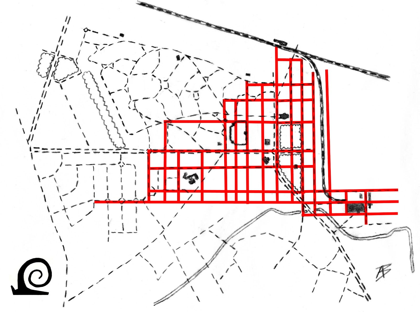
The original grid of the colliery forms the basis for
the area around the Meridiaanlaan and the production site itself. What is
surprising is that the later garden village layout in part also uses the old
grid and transforms it. This is clearly visible when the gridlines are
projected on the street pattern. Especially the amenities (church, school and
tennis courts) still have a link with the grid. The director's villa is placed
centrally on the crossing point of two gridlines.
After 1920 plans were drawn up for expanding the
mining colony. To this end the André Dumontlaan and Duinenlaan were constructed
to link the site to the thoroughfare Genk - As. The Genk-Waterschei train
station was built at the end of the Duinenlaan (Dune Avenue, as it lead to the heath) in 1925. Perpendicular to the
Duinenlaan (and thus the older colliery grid)
a new broad avenue was planted: the Onderwijslaan. This avenue ended abruptly at
the point where the belt road of the garden village called Tuinwijk André
Dumont starts. This Ceintuurlaan curves back to the Duinenlaan. The
Binnenlaan (literally: Inner Avenue)
divides the garden village east - west. The streets follow a curved alignment
reminiscent of park design of the day. South of the Onderwijslaan along an
existing route along the Stiemerbeek called Stalenstraat (named after the
medieval mansion of Stalen) developed into a commercial district serving the
garden village. There was no space allotted for commercial venues (shops,
bakery, barber, greengrocer etcetera) within the garden village. Here only
amenities were planned and provided buy the mining company. This pattern is
seen in all Campine mining colonies.

The street pattern of the garden village follows a
simple plan with two avenues along the older grid connected by a belt road
(Centuurlaan) and divided by a secondary central road (Middenlaan). The edge of
the garden village was determined by the Stalenstraat to the south, the railway
line to Zwartberg in the north and the Hoevenzavel to the west.
Between the Stalenstraat and the Onderwijslaan the
Tuinwijk-Zuid was developed. It follows a strict street layout of parallel main
streets with roundabouts connecting the side streets. After 1944 the central
avenue dividing the garden villages to the north and south was extended to join
the extended central avenue (Hoevenzavellaan)of the Zwartberg colliery.

No comments:
Post a Comment